
Del Pino Hotel & Resort Ocean Play (델피노호텔&리조트 오션플레이)
16.1 Km 68802 2024-02-22
1153 Misiryeongyet-gil, Toseong-myeon, Goseong-gun, Gangwon-do
Del Pino Hotel & Resort Ocean Play is a themed water park where visitors can enjoy water playground and spa treatments with hot spring water all year round. It features indoor and outdoor zones, hot springs, and open-air baths. For children, there are Kids' Play Pools, a Kids' River, and an Outdoor Infinity Pool with shallow depths. The indoor area offers panoramic views of the Sokcho coastline through expansive floor-to-ceiling windows.
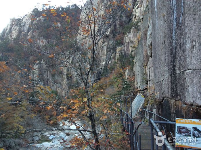
Cheonbuldong Valley (천불동계곡)
16.4 Km 29791 2021-04-09
1091, Seoraksan-ro, Sokcho-si, Gangwon-do
+82-33-801-0900
As one of the Ten Sights of Seoraksan Mountain, the Cheonbuldong Valley is also called Seorakgol Valley, being a representative valley of the mountain. Along the valley covering about 7 km from Biseondae Rock to Daecheongbong Peak, visitors can enjoy the splendid scenery of various attractions including Waseondae Rock, Munjudam Pool, Ihodam Pool, Gwimyeonam Rock, Oryeon Falls, and Cheondang Falls. It has all magnificent views of Seoraksan Mountain. The Cheonbuldong Valley is also regarded as one of Korea’s top 3 valleys along with Chilseon Valley of Jirisan Mountain and Tamna Valley of Hallasan Mountain. It offers beautiful seasonal views every year, and among them, the autumnal foliage is considered the best scenery of the valley. Its colorfully-tinged autumnal leaves are in harmony with rocks in fantastic shapes, attracting many hikers in autumn.
Geumganggul Cave (금강굴)
16.4 Km 28146 2019-11-27
1091, Seoraksan-ro, Sokcho-si, Gangwon-do
+82-33-801-0900
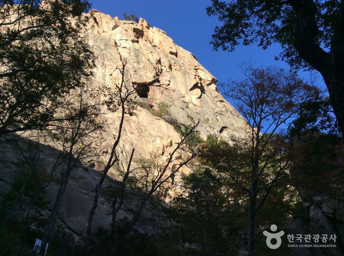
Hollowed into the rocks of Seoraksan Mountain, about 600 meters above sea level, you will find Geumganggul Cave. This 23 square meters cave was once used as a place of worship, and contains a stone sitting Buddha and some earthenware. The route up the cave is quite steep, and visitors must walk across a few bridges and up concrete stairways. However, you will be rewarded with a captivating view of Cheonbuldong Valley.
The hiking trail from Seorakdong to Geumganggul Cave, which also passes by Biseondae, is 3.6 kilometers long and takes about 1 hour and 40 minutes.
Biseondae Rock (비선대)
16.4 Km 19608 2021-04-09
1091, Seoraksan-ro, Sokcho-si, Gangwon-do
+82-33-801-0900
Biseondae Rock is a large rock located in the Cheonbuldong Valley of Seoraksan Mountain. The rock blended with a giant surrounding rocky wall creates a mysterious atmosphere. When it rains, water flows down through the rock and forms a small waterfall. The stream of water winding around the rock is considered the magnificent view, which is similar to that of the Manpokdong Valley in Geumgangsan Mountain. When the season changes, its landscape boasts different scenery: full-blown flowers in spring, green and refreshing trees in summer, colorful autumnal leaves in autumn, and white snowy view in winter. Due to such a mysterious landscape, Biseondae Rock bears a legend in which Taoist hermit called Magoseon enjoyed scenery of this place and ascended to heaven. The name of Biseondae, meaning the rock (dae) where a Taoist hermit (seon) flew up (bi) to the sky, originates from this legend.
Seoraksan Cable Car (설악산 케이블카)
16.4 Km 78221 2024-04-08
1085 Seoraksan-ro, Sokcho-si, Gangwon-do
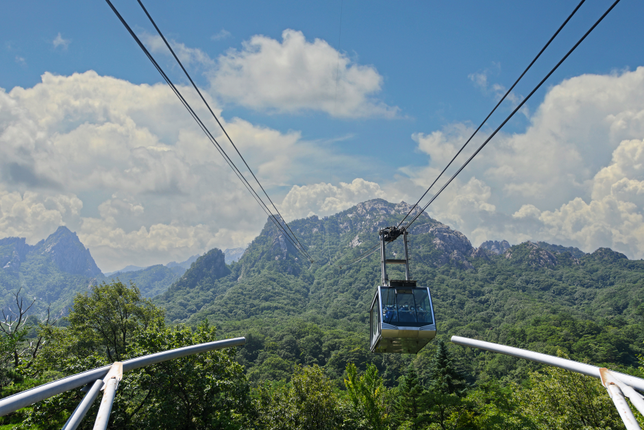
A ride on the Seoraksan Cable Car is the best way to enjoy the unexplored regions of Seoraksan Mountain. The cable car station is located in Seoraksan National Park, and it takes about 10 minutes to reach Gwongeumseong Fortress, which is 700 meters above sea level. Since one-way tickets are not available, passengers must purchase a round-trip ticket. From the cable car window, passengers can see famous attractions like Ulsanbawi Peak and Manmulsang Rocks. From Gwongeumseong Fortress, passengers can take in a panoramic view of Seoraksan Mountain. Seoraksan Mountain, seen from the top of Gwongeumseong Fortress, is majestic and mysterious with unique rock formations. Upon reaching the top of the mountain, the entire scenery of Outer Seorak unfolds before one's eyes. Visitors will be amazed by the Allak Hermitage from the Silla dynasty and the Muhagsong Pine Tree, which has survived for hundreds of years just below Gwongeumseong Fortress. There are many tourists on weekends, public holidays, and fall foliage season, so visitors are advised to plan ahead.
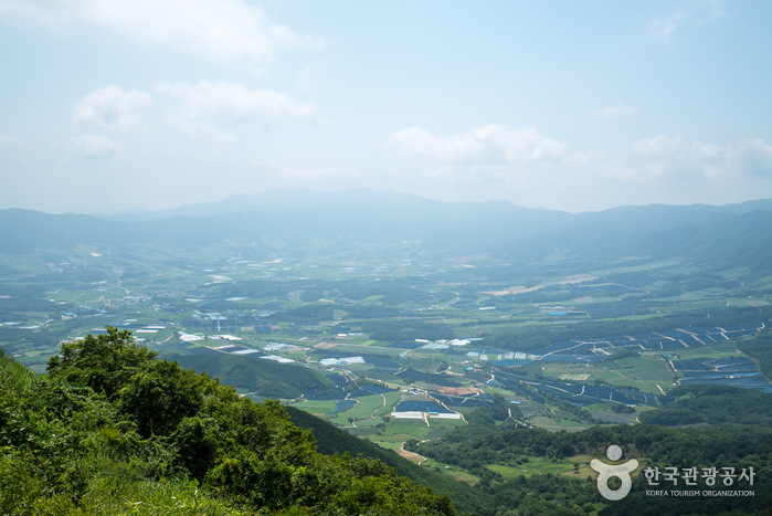
Gachilbong Battlefield (가칠봉지구전투전적지)
16.7 Km 28951 2020-04-02
Haean-myeon, Yanggu-gun, Gangwon-do
+82-33-480-2675
The entire
town of Haean-myeon is contained in Haean Basin. Also known as Punch Bowl, Haean
Basin is surrounded by high peaks and one of these peaks is Gachilbong.
The
nature of the terrain in the Gachilbong area made it difficult to conduct
military operations during the Korean War. The North Korean military utilized these natural features to build a solid defense position and launch counterattacks, while the
South Korean soldiers in the lowland were in a disadvantageous position. South Korean soldiers were under the command of 5th
Division Commander Brigadier General Min Gi-sik and 24th Regiment Commander
Colonel Yu Ui-jun. On the North Korean side, the 7th, 14th, and 32nd Regiments of the
27th Division and the 23rd Regiment of the 12th Division under the 2nd Corps fought back.
By
sending a military deployment and conducting search operations, the
South Korean military completed a reconnaissance of the area on August 30 and
advanced to counterattack. On August 31, after defending their position for two
days, the South Korean soldiers were able to break the North Korean resistance.
Each unit secured a strongly fortified position to draw the North Korean
soldiers out. Thereafter, South Korea launched an all-out attack and captured Hill
1241. However, North Korea attacked again and South Korea retreated. After several attacks and counterattacks,
South Korea was able to take back Gachilbong and the surrounding areas. Although
it resulted in heavy casualties on both sides, this battle ultimately
gave South Korea possession of Haean Basin.
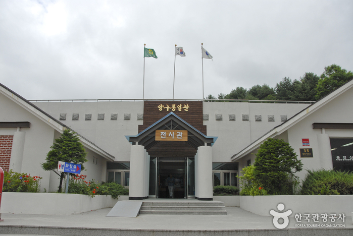
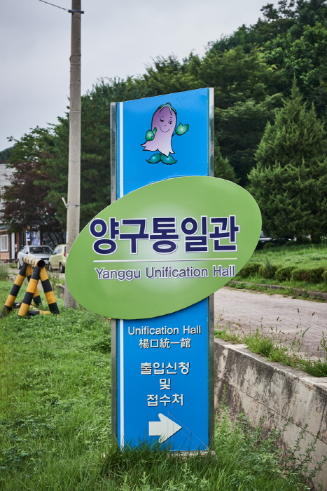
Yanggu Unification Hall (양구통일관)
16.9 Km 27437 2021-09-10
35, Haeanseohwa-ro, Yanggu-gun, Gangwon-do
+82-33-481-9021
The Yanggu Unification Hall is located in the northernmost part of the Civilian Control Zone in Haean-myeon, Yanggu-gun. It was built and opened to be utilized as a unification education center that would help broaden people’s understanding about the real situation in North Korea in preparation for reunification and encourage commitment for reunification. The location is 5 kilometers away from The 4th Tunnel, in the northern end of the punch bowl basin and it first opened in 1996. It has a first exhibition hall, second exhibition hall, agricultural specialty market, and a parking lot that can accommodate about 100 vehicles.
Directly operated by Yanggu-gun District Office, the Yanggu Unification Hall displays materials that show the reality of North Korea including household goods, exports and photographs. The agricultural specialty market sells agricultural goods, North Korean products, and tourism souvenirs. Located nearby are The 4th Tunnel, Eulji Observatory, and War Memorial Museum in Yanggu. Eulji Observatory is the northernmost located observatory in South Korea. The 4th Tunnel is the only tunnel among the four tunnels dug by North Korea that operates electric cars, allowing visitors to travel inside. The War Memorial Museum in Yanggu was built to shed new light on the nine battles fought in Yanggu during the Korean War. The Yanggu Unification Hall deals with works related to the Eulji Observatory, The 4th Tunnel and War Memorial Museum in Yanggu.
Yanggu War Memorial Hall (양구전쟁기념관)
16.9 Km 28390 2022-10-14
35, Haeanseohwa-ro, Yanggu-gun, Gangwon-do
+82-33-481-9021
Opened June 20, 2000, the Yanggu War Memorial Hall was built to commemorate the sacrifice and heroism of those who fought during the Korean War at the nine battlefields located in Yanggu: Dosolsan, Daeusan, Bloody Ridge, Baekseoksan, Punch Bowl, Gachilbong, Danjang Ridge, 949 Hill, and Christmas Hill. The museum also reminds the current and future generations of the real cost of war and the sacrifices that were made.
The exhibition hall is divided according to themes: freedom, welcoming, meeting, understanding, experience, assurance, tribute, rooftop, and contemplation. Exhibition facilities include a high-quality imaging system and a three-way multi-imaging room that combines battle scene dioramas, videos, and slides.
Seoraksan National Park (Outer Seorak) (설악산 국립공원 (외설악))
16.9 Km 449695 2024-04-08
1 Daecheongbong-gil, Yangyang-gun, Gangwon-do
+82-33-801-0900
Seoraksan Mountain is renowed for its natural splendors and breathtaking views. It holds the distinction of being Korea's first UNESCO Biosphere Reserve and is also listed on the IUCN Green List. The mountain is divided into Inner Seorak, South Seorak, and Outer Seorak, which includes Daecheongbong peak (1,708 meters above sea level), ranking as the third highest peak in Korea. The area is celebrated for its popular hiking trails, with the sunrise and sunset views from the top being particularly spectacular.
Eulji Observatory (을지전망대)
16.9 Km 25718 2022-10-14
621, Hu-ri, Haean-myeon, Yanggu-gun, Gangwon-do
+82-33-481-9021
Eulji Observatory, located near the Military Demarcation Line along the ridge of Gachilbong Peak, is now one of the most informative sites dating back to the Korean War. From Eulji Observatory, visitors can see North Korean land from afar as well as Birobong Peak of Geumgangsan Mountain. It is the northernmost DMZ attraction and over 100,000 people visit this observation platform every year.
 English
 한국어
한국어 日本語
日本語 中文(简体)
 Deutsch
 Français
 Español
 Русский