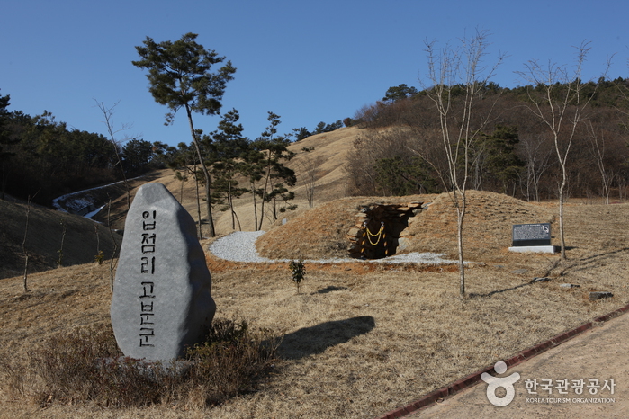
Iksan Ipjeomni Ancient Tombs (익산 입점리 고분)
11.8 Km 7115 2024-04-07
80, Ipjeomgobun-gil, Iksan-si, Jeonbuk-do
+82-63-859-5875
The Iksan Ipjeomni Ancient Tombs are a group of ancient Baekje-era tumuli located 100 meters above sea level on the northeast brow of Chilmokjae Hill in Ipjeom-ri, Iksan-si, Jeollabuk-do. The burial ground covers an area of more than 18,520 square meters and is officially listed as Historical Site No. 347. To date, a total of eight tumuli have been excavated, all of which are chamber tombs.
Surprisingly enough, the tombs were first discovered in 1986 by a high school student. While digging for arrowroot, a young man from a local high school found some pieces of gold that resembled a hat. He quickly notified the authorities and it was soon discovered that the pieces of gold were in fact valuable ancient artifacts. An emergency excavation was conducted and the eight tumuli were uncovered, but unfortunately all of the tumuli except Tomb No. 1 had been severely damaged. Tomb No. 1, which is still in relatively good condition, boasts an entrance measuring an impressive 16 meters in x_height and 2 meters in x_width.
Inside the tombs archaeologists found valuable relics from the Baekje dynasty including earthenware, jewelry (a gilt-bronze hat, gold earrings, glass beads, etc.), harnesses and ironware. Given the shapes and the types of the pieces found, historians estimate that the tumuli were built in the 5th century. Since the gilt-bronze hat is similar in shape to those found in Japan, experts believe that there was an active exchange between the Baekje people and the people of Japan.

SO-DAM(소담)
14.3 Km 0 2021-02-19
15-9, Chungjeol-ro 41beon-gil, Seocheon-eup, Seocheon-gun, Chungcheongnam-do
+82-41-951-7272
This is a Korean cuisine located in Seocheon-gun , Chungcheongnam-doA Korean BBQ restaurant.The representative menu is Grilled Special Cuts.
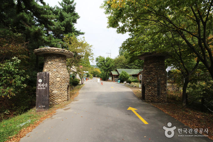
Huirisan Pine Tree Recreational Forest (국립 희리산해송자연휴양림)
14.7 Km 42079 2022-07-22
+82-41-953-2230
Surrounded by majestic pine trees, Huirisan Mountain boasts an outstanding landscape; there is a reservoir at the foot of the mountain. Upon climbing to the top of the mountain, visitor can overlook the scenic West Sea. There are also numerous attractions near Huirisan: Chunjangdae Beach, Geumgang River Banks, and Hansan Mosi Town (“Mosi” referring to “Ramie,” the predominant fabric used for traditional Korean clothing)
The top of the mountain (329m in x_height) is called Munsubong (or Munsu Peak). To the northwest of the Huirisan Pine Tree Recreational Forest is Saindae. Legend goes that four generals used to play there. Indeed, there is a cliff (140m in x_height) just below Saindae where they were believed to do chin-ups. Naturally, people call the area Teokgeolijang (Chin-Up Spot). Traces of Munsusa Temple still remain below Munsubong although it was said to have been destroyed by a huge number of bedbugs. 500m from Munsubong to the south, horse riding trails of the four generals are dotted along the ridge; Malttongbawi (Horse Dung Rock), resembling horse droppings, is 500m from the peak to the southeast.
Below Munsubong are four large peaks where the four generals lived and 100 small rocks beneath them that were home to low ranking men commanded by the generals. Because of their unique shapes, those rocks form a scenic sight while hiking in Huirisan.
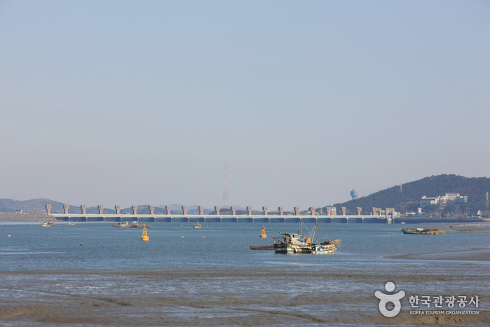
Gunsan Geumgang Estuary Bank (금강하구둑(군산))
14.9 Km 39486 2024-04-07
120, Cheolsae-ro, Gunsan-si, Jeonbuk-do
+82-63-454-3353
Geumgang Estuary Bank was completed in 1990 as part of an agricultural development project for 6 cities and counties in Chungcheongnam-do and Jeollabuk-do. The Korea Agricultural and Rural Infrastructure Corporation invested approximately 100 billion won for the project and the construction lasted for 8 years. The estuary bank can hold up to 130 million tons of water. The 1,840-meter long bank serves a bridge that connects Chungcheongnam-do to Jeollabuk-do.
Aside from being the source of water for agricultural and industrial use in Jeollabuk-do and Chungcheongnam-do, the bank also provides flood control for the area around Geumgang River. It helps keep Gunsanhang Port operational by preventing soil
and sand from accumulating at the mouth of the river. It also prevents the backwash of seawater from causing damage to farmlands. Geumgang Estuary Bank has an important role as a tourist destination by connecting Gunsan and Janghang.
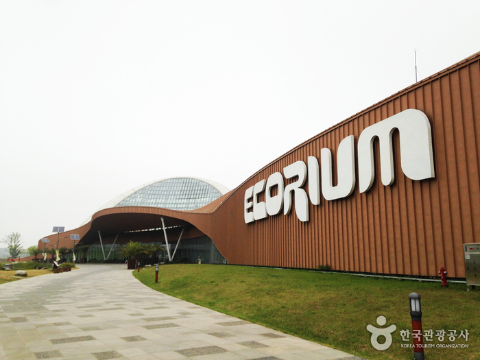
National Institute of Ecology - Seocheon (국립생태원(서천))
15.6 Km 15479 2020-05-18
1210, Geumgang-ro, Seocheon-gun, Chungcheongnam-do
+82-41-950-5300
National Institute of Ecology is a research, exhibition, and educational center housing various animals and plants from world five climates and regions including the tropics, desert climate, the Mediterranean, temperate climate, and the polar region. Fauna and flora from the Korean Peninsula's ecosystem can also be seen here. The Institute’s Ecorium showcases living ecosystem exhibitions, housing 1,900 plants and 280 animals in an area of 21,000㎡ to help people understand the relations between climate and ecology. The outdoor exhibition area is divided into 5 sections, from Korea’s representative wetland ecological system to various international plants, rare plants grown on the high mountain, Korean representative deer species' habitat space, pond ecology and others. In addition, it offers vivid ecological education through the nearby ecological region and has varied exhibitions and researching facility as well as firsthand programs and events.
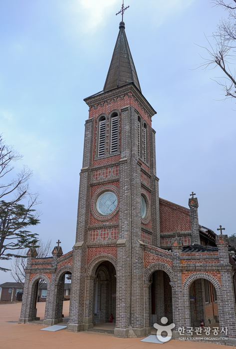
Nabawi Catholic Church (화산천주교회(나바위 성당))
15.6 Km 9117 2024-04-07
146, Nabawi 1-gil, Iksan-si, Jeonbuk-do
+82-63-861-9210
Nabawi Catholic Church is located in Hwasan-ri, Mangseong-myeon in Iksan, Jeollabuk-do Province and is known as the oldest surviving catholic church in the Jeolla-do region. The church was built in 1906 to commemorate the return of priest Kim Dae-geon in 1845 (Joseon dynasty) after he was ordained in Shanghai, China. Inside the church stand two monuments: one built in 1954 to honor Joseph Vermorel (French missionary, 1860-1937) and one built in 1955 to honor priest and martyr Kim Dae-geon. Considered the most significant catholic relic of the Jeolla-do region, the church is sought out by large numbers of Catholic visitors each year.

Seodong Park and Gungnamji Pond (서동공원과 궁남지)
15.9 Km 30235 2024-06-04
52 Gungnam-ro, Buyeo-gun, Chungcheongnam-do
+82-41-830-2953
Gungnamji Pond, a Historic Site located in Seodong Park, is Korea’s first artificial pond and was created by King Mu from the Baekje dynasty, who fell in love with and eventually married Princess Seonhwa. Gungnamji, literally means a pond in the south of the royal palace in Korean, was the given name according to the Samguksagi records.
According to a record in the Samguksagi, the History of the Three Kingdoms, King Mu dug this lake south of his palace in the 35th year of his reign (634) and connected it by a 7800-meter long waterway to the water source. The king then had willow trees planted around the bank and had an artificial mound constructed in the middle of the lake.
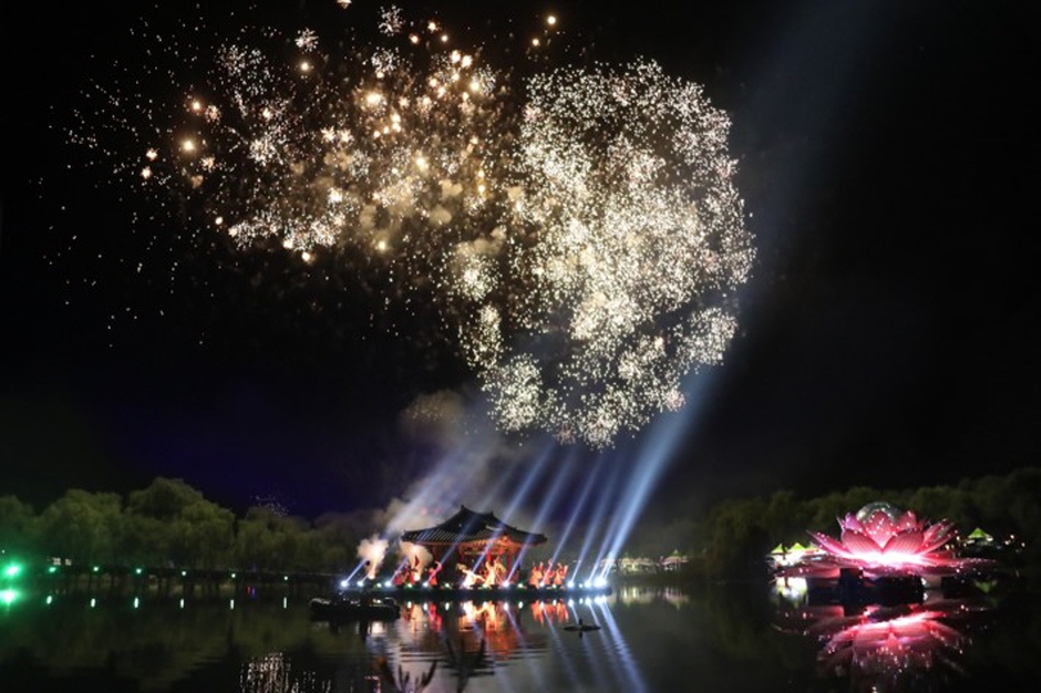
Buyeo Seodong Lotus Festival (부여서동연꽃축제)
15.9 Km 74558 2022-05-04
52, Gungnam-ro, Buyeo-gun, Chungcheongnam-do
• 1330 Travel Hotline: +82-2-1330 (Korean, English, Japanese, Chinese) • For more info: +82-41-830-2208
Buyeo Seodong Lotus Festival has been designated as an excellent festival four years in a row by the Ministry of Culture, Sports and Tourism. The festival takes place every July during the summer's peak when the lotus flowers bloom. The festival is based on a historical love story, with programs and performance events focused on story delivery. The festival venue is designed to fit in with the natural settings nearby, serving as a perfect backdrop for taking memorable photos with families and friends.
Deoksugung Haemul Kalguksu (덕수궁해물칼국수)
16.1 Km 20616 2024-02-28
5, Jangsan-ro 855beon-gil, Maseo-myeon, Seocheon-gun, Chungcheongnam-do
041-956-7066
Located near the Geumgang Estuary Embankment, Deoksugung Haemul Kalguksu serves haemul kalguksku (noodle soup with seafood) full of clams and vegetables. Kalguksu (noodle soup) is made by rolling out a thin flour dough, slicing it into thin strips, and then boiling them in a soup. There’s a variety of kalguksu (noodle soup) dishes on offer, along with wangmandu (jumbo mandu). The broth is clean, thanks to shrimp and fresh vegetables. Don’t miss yeolmu kimchi (young summer radish kimchi), which is served as a side dish in the restaurant and goes perfectly with kalguksu (noodle soup).
![Buyeo Naseong Fortress [UNESCO World Heritage] (부여 나성 [유네스코 세계문화유산])](http://tong.visitkorea.or.kr/cms/resource/71/2725771_image2_1.jpg)
Buyeo Naseong Fortress [UNESCO World Heritage] (부여 나성 [유네스코 세계문화유산])
16.3 Km 27294 2021-07-22
100-11, Dongmun-ro142beon-gil, Buyeo-gun, Chungcheongnam-do
+82-41-830-2623
Buyeo Naseong, also known as the Outer City Wall, was built to protect the capital of Baekje, Sabi. It has a x_height of about 8.4 kilometers. The wall surrouned Busosanseong Fortress and extended to the city of Buyeo.
The wall is one of the oldest walls along with Naseong in Pyeongyang and it is estimated to have been built around 538, when the Baekje capital was changed from Woonjin (current Gongju) to Sabi (current Buyeo). The wall of the fortress starts from the site where Dongmun (East gate) was located to the area of Geumgang River, made by piling soil up. However, only a few traces remain of its former glory.
For now, it leaves a blurry trail including a 20 meter area to the east of Cheongsanseong Fortress, Dongmun Bridge from Seokmok-ri, and an area from Pilseobong Peak to Yeomchang-ri. While the outer wall is sharply sloped, the inner wall was built with a gentle slope to make it easier for horses to reach the guard posts on the top of the wall. Inside the fortress, the palace of Baekje, government offices, houses, temples, stores and protected facilities can be seen. The entire structure of Naseong Fortress features Geumgang River in the south and west sides, providing a natural double-defense system. The wall was one of the important outer defense facilities along with Cheongsanseong and Cheongmasanseong Fortresses.
* Area: 554,591 ㎡
 English
 한국어
한국어 日本語
日本語 中文(简体)
 Deutsch
 Français
 Español
 Русский